Itinerary & Waypoints
|
Daily Distances
|
|
- Day 1: 52km...Three Valley Gap to Cottonwood Bay, east side of Mabel Lake (except for the first 3km on the TCH, all loose surface road conditions today)
- Day 2: 33km...Cottonwood Bay to River Lea campground on Shuswap River south of Mabel Lk (1st 2okm loose surface, then 13km paved)
- Day 3: 81km...River Lea to Kingfisher, west side of Mabel Lake (all paved road today)
|
- Day 4: 78km...Kingfisher to Sicamous (all paved road today)
- Day 5: 45km...Sicamous to Three Valley Gap (all paved road today)
|
Other than the meeting time of 9AM on the first day of the trip at the Three Valley Chateau
to find the place to park our vehicles, there will be NO SET TIME for anything else.
Leave when you want each morning and arrive in the next camp when you want.
Day 0, Thurs, Aug 2, 2001
Sojourn where you like or drive out early the next morning.
Meet at the Three Valley Gap Chateau at the east end of
the Three Valley Lake, 20km west of Revelstoke.
|
|
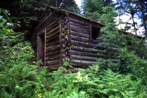
Old cabin near Wap Lake
Photo Credit: P. LaGrandeur July, 1999
|
Day 1, Fri, Aug 3, 2001: Three Valley Gap - Mabel Lake / Cottonwood Bay
BC Forest Camp Site via Hwy 1 TransCanada (paved with wide shoulders) (~3km), Three Valley/Mabel
Lake Forest Service Road (gravel 18km) and Mabel Lake Forest Service road (gravel 31km).
Cottonwood Bay is roughly halfway down the east side of Mabel Lake and is directly across from the
village of Kingfisher on the west side of the lake. The access to Cottonwood Bay Rec
Site is about three kilometres south of Tsuius Creek/bridge. From there, it is about two
kilometres north to the camp site.
Day 1 Waypoints:
Plan to be fed, organized and ready to go by 9AM. Meet at the Three Valley Gap restaurant.
Those who want breakfast can meet at the restaurant at 8AM.
The Tour Co-Ordinator will liase with the hotel management to find the parking place for us.
DO NOT just leave them anywhere.
The Chateau proprietor will SHOW US where to park our vehicles.
Let's not wear out our welcome.
0km Three Valley Chateau. The owner has kindly offered to let us park our cars there for
the five days we are away. There will be no charge but he will also take no responsibility
for their well being. Perhaps show your appreciation by overnighting and/or having breakfast at his hotel.
Upon our arrival the owner, George Bell, will show us where to park our vehicles.
If you arrive late, either look for other cyclists' vehicles or ask George where to park.
3.5km junction. Turn left onto the Three Valley/Mabel Lake BC Forest Service Road.
8km "Frog Falls" BC Forest Service camp ground on the left
|
|
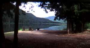
Wap Lake
Photo Credit: P. LaGrandeur July, 1999
|
15km "Wap Lake" BC Forest Service recreation site and campground.
21km junction. Leave the Three Valley/Mabel Lake Forest Service road which continues to the
right (west) and take the Mabel Lake Forest Service road which goes south. A map board
is probably there to assist in recognizing the junction.
48km Tsuius Creek bridge
50km junction. Turn right off the Mabel Lake FSR unto the access road to Cottonwood Bay BC
Forest Service Recreation Site and campground. From there it is two kilometres north to the
camping and beach area.
52km Cottonwood Bay recreation site
Day 2, Sat, Aug 4, 2001: Cottonwood Bay - Bigg Creek / River Lea
Campground via Mabel Lake Forest Service Road (20km gravel to the access of Mabel Lake
Provincial Park and paved 13km from there to Lawrence Road, the kilometre-long gravelled
access to River Lea Campground nestled on the east bank of the Shuswap River. Pass by
Cascade Falls.
Day 2 Waypoints:
|
|
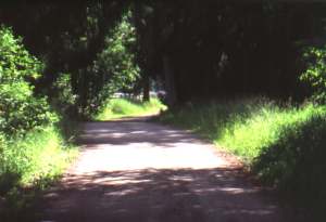
Entrance to River Lea campground
Photo Credit: P. LaGrandeur July, 1999
|
0km Cottonwood Bay Rec Site
2km junction. Access to Mabel Lake Forest Service Road.
15km Cascade Falls access and area of the two "Cascade South" BC Forest Service Rec Sites
and campgrounds
20km junction. Access to Mabel Lake Provincial Park . A nice place to visit and stay a while.
32.5km junction. Sigalet Road on left. Don't turn here.
33km junction. Turn right onto Lawrence Road and follow the classic tree tunnelled road to the
Shuswap River to private River Lea Campground.
|
|
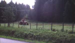
Tractor man
Photo Credit: P. LaGrandeur July, 1999
|
Day 3, Sun, Aug 5, 2001: via Mabel Lake Forest
Service Road (paved with narrow shoulders), Trinity Valley Road ("paved"), and
Enderby/Mabel Lake Road(paved with narrow shoulders).
Day 3 Waypoints:
0km River Lea Campground
5km Mabel Lake hamlet
8km Shuswap Falls, Shuswap River Drive
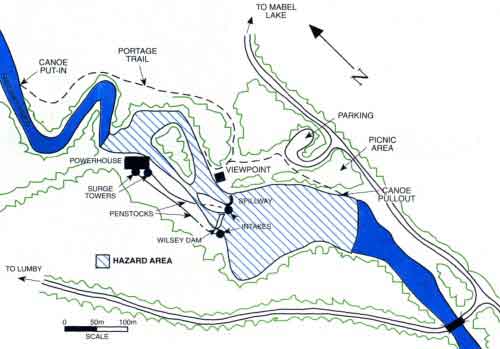 Don't pass by this place without stopping in to see the viewpoint overlooking the dam.
13km Rawlings Lake Road
19km junction. Turn right onto Trinity Valley Road. Those cyclists who opt for a side trip may
continue straight through (west) on the Mabel Lake Road will arrive by taking a side trip to
Lumby about 5km farther on. If so, retrace the route to get back to the Trinity Valley road.
33km access on right to Trinity Valley hamlet about a half kilometer in
51km junction. Hidden Lake Road to right. Do not turn right.
55km bridge over Shuswap River
57km junction. Ashton Creek at intersection with small general store. Turn right (east) unto
Enderby/Mabel Lake Road.
81km Kingfisher Campground private campground on left (north) side of road. Note that
KF campground is about 2km west of Mabel Lake. We are not staying at the campground at Mabel Lake.
Day 4, Mon, Aug 6, 2001: Kingfisher - Sicamous via Enderby/Mabel Lake
Road (narrow or no shoulders)(32km) and Hwy 97/97A (narrow or no shoulders)(41)km
and east on Trans Canada Hwy #1 (wide shoulders)(5km).
Day 4 Waypoints:
0km Kingfisher Campground
23km Ashton Creek
32km junction. Enderby/Grindrod Road (just before bridge over Shuswap River).
40km Grindrod village to left. Do not turn left.
73km Sicamous on Hwy 1 Trans Canada highway. Turn right and travel east on TCH.
78km Homestead campground on left (south) side of highway between TCH and Eagle River.
Day 5, Tues, Aug 7, 2001: Sicamous - 3VG via Hwy 1 (TransCanada) (wide shoulders).
Day 5 Waypoints:
0km Homestead campground
20km Craigellachie "Last Spike Monument"
45km Three Valley Gap Chateau. End of trip.
|