Itinerary
|
Can we plan to roll out of camp every day by 8AM? This way we can get a
good start on our day's kilage before the heat of the day settles in.
There will be times when a proper bridge is not available for crossing
water courses due either to the bridge having been removed or its
approaches washed out. Be prepared to have occasional wet feet.
-
Day 0 (Thurs., Aug 5):.........arrival in Penticton
Today is our positioning day where we prepare for launch the next morning.
Find the campground and check in. We will be next to a water slide so consider
trying that out, especially since Penticton is likley to be a warm place
that time of the summer. Get a good night's rest.
-
Day 1 - 58km (Fri., Aug 6):.........
Today is the big day. Highlights of the day include the highest bridge in the
entire Kettle Valley system and riding the steam train for 15km. Bring lots
of money in case there are train robbers asking for donations to charity.
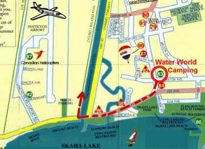
From the Water World Campground, head out the front gate to the right onto
Yorkton Avenue. Then make an immediate left onto Skaha Lake Road (Hwy 97).
Continue west to the west edge of the canal. Follow this north 5.5km to
Eckhardt Avenue W then turn left. Follow this west across the canal about 100 meters
and hang an immediate left onto West Bench Drive. From there it is about
half a kilometer to the KVR.
The trail climbs from here up to the Trout Creek bridge. We take the
steam train from the south end of the trestle.
Be at the station by 11:10 at the latest.
It pulls out at 11:30, with or without us.
Cost of this is included in your EVCC trip fee.
The choo choo will take us 15km to the Faulder
station. Our bikes will be carried in the baggage car.
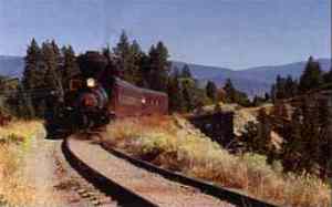 The Kettle Valley Steam Railway offers a unique journey on
one of British Columbia's few remaining fully operational
steam railways. Powered by a 1924 Shay steam locomotive,
passengers enjoy a tour along a preserved ten kilometre
section of the original railway constructed from 1910 to 1915.
The locomotive pulls two 1950's passenger cars, the "Kettle Kar"
(open-air) and the Kaboose.
The Kettle Valley Steam Railway offers a unique journey on
one of British Columbia's few remaining fully operational
steam railways. Powered by a 1924 Shay steam locomotive,
passengers enjoy a tour along a preserved ten kilometre
section of the original railway constructed from 1910 to 1915.
The locomotive pulls two 1950's passenger cars, the "Kettle Kar"
(open-air) and the Kaboose.
Friendly, informative guides bring
the history of the railway alive as the train chugs along
hillsides overlooking beautiful Okanagan orchards and vineyards.
The Trout Creek Bridge which spans the canyon at 241 feet above
the water (the highest trestle on the original KVR lines) can be
viewed from the southern terminus of the railway. The train also
features a concession booth.
The Steam Train is boarded at the Prairie Valley Station in Summerland,
with stops at each end at Canyon View (the south end of Trout Creek
trestle) and Faulder.
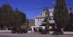
Prairie Valley station is located near the Summerland Rodeo Grounds,
which provides a
rustic setting where Special Events are held throughout the
operating season.
The Prairie Valley Station also houses an information centre
and unique souvenir gift shop "The Whistlestop", and all
facilities are wheelchair accessible. The site also provides
spacious bus parking areas for easy loading and unloading.
From Faulder,
we pedal onwards towards our camp for the night at the BC Forestry
Service campsite at Thirsk Lake. The only challenge for today
will be the second Trout Creek crossing about 12km west of Faulder.
The bridge is now gone and we will have to take a trail down to the
bottom of the water course and up again the other side.
The day's distance is 58km, but we will be pedalling only about 43km
of that due to the train ride.
-
Day 2 - 55km (Sat., Aug 7):.........
Our day is mostly straight forward. There will be a general store and
restaurant at Bankier, about 11km west of Thirsk Lake campground.
Continue on to the Princeton Castle Resort located next to the rail
trail. This 'castle' is the ruins of a former cement plant.
-
Day 3 - 59km (Sun., Aug 8):.........
Onwards and upwards! We carry on through Coalmont and Tulameen today.
A few small washouts to hump through and we will be at Burt's Horse Motel.
Tnere is no phone at Burt's so Tulameen will be the last place we can make
contact with our stock brokers for the day.
-
Day 4 - 36km (Mon., Aug 9):.........
Today is the day we swing south into the Coquihalla canyon. Past Brodie, the
right of way of the former KVR is now owned by Transmountain Pipelines of
Vancouver. They have said that cyclists may travel this route, including any
access roads for our entire route today to Coquihalla Lakes. We will stick mainly
with the itinerary as laid out in the Langfords' book.
-
Day 5 - 56km (Tues., Aug 10):.........
Shortly after leaving the Coquihalla Lakes Lodge & Campsite this morning, we will
have to divert up to the Coquihalla Highway, BC #5, as far as the Portia station.
The reason for this is the construction that will be taking place with
the TMP. Thay say there will be a great deal of heavy equipment working on
the road and, after a very close call last summer between a mammoth rock
truck and a group of cyclists, they are asking that all bikers (and all
other non-company personnel) find alternate passage through the area.
From Portia, we will continue the ride on and off the rail bed
as per the Langford book. We regain the trail again for the last time today
at the access point to the Othello tunnel road. This is a spectacular section,
named by the railway builder, Andrew McCulloch, after a character in
Shakespeare's literary
world. In more recent times, this is where much of the movie 'Rambo, First Blood'
was filmed. We will roll into Hope, and stay at the Coquihalla Campsite for the
night.
Some of the route we will be doing on this day remains to be decided due to
construction, as noted above. We will be in contact with TMP and local cycling
enthusiasts who will keep us better informed when the time comes as to
exactly where we should and should not ride.
Once the pipe line work is done in a few years, it looks favourable for the
implementation of a formal recreational trail for bicycles, horses, ATV's, etc., as
part of the Trans Canada Trail system.
-
Day 6 - 47km (Wed., Aug 11):.........
Plan to board the bus today at 08:30AM at the campground. It will take us and
our bicycles up north to where we turned south at Brodie. Attach your bags back
onto the bikes, and we will head north to Merritt. As indicated in the Langford's
book, we will have to detour around the Coldwater Indian Reserve. This is due partly
to the reluctance of the band to entertain cyclists, but also mainly due to
the Coldwater River having washed out much of the rail bed and bridge approaches.
Merritt has a very nice aquatic center, so those arriving during the heat of the day
will likely want to check out this attraction.
-
Day 7 - 72km (Thurs., Aug 12):.........
 Today we start with pavement on Hwy 5A east for about 25km. The rail bed heading east from
Merritt seems to have been taken over by ginseng ranches and the like so we have
to ride the asphalt. We will pass the hamlet of Quilchena, a long established picturesque
hotel which now
features a golf course and RV park. Be sure to stop in and have a look at the old building.
Just past Quilchena at the east end of Nicola Lake, we take a right onto the loose surface
road to Douglas Lake Cattle Country. The road is excellent today for cycling, all the way to Salmon
Lake.
Today we start with pavement on Hwy 5A east for about 25km. The rail bed heading east from
Merritt seems to have been taken over by ginseng ranches and the like so we have
to ride the asphalt. We will pass the hamlet of Quilchena, a long established picturesque
hotel which now
features a golf course and RV park. Be sure to stop in and have a look at the old building.
Just past Quilchena at the east end of Nicola Lake, we take a right onto the loose surface
road to Douglas Lake Cattle Country. The road is excellent today for cycling, all the way to Salmon
Lake.
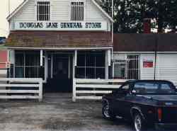 Be sure to stop in at the Douglas Lake General Store. This property was
previously owned by the Woodward family of Vancouver, who had the Woodward's chain
of department stores. An original horse drawn delivery wagon from the Vancouver store
in still on display beside the store. This is a place to pick up some provisions
in case you get to Salmon Lake Resort and its general store before it closes at 5PM.
Be sure to stop in at the Douglas Lake General Store. This property was
previously owned by the Woodward family of Vancouver, who had the Woodward's chain
of department stores. An original horse drawn delivery wagon from the Vancouver store
in still on display beside the store. This is a place to pick up some provisions
in case you get to Salmon Lake Resort and its general store before it closes at 5PM.
-
Day 8 - 78km (Fri., Aug 13):.........
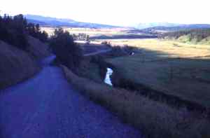 We have gravel to ride on as far as Hwy 97.
A short 7km brings us to the gravel access road to BC Forest Service's
Pinaus & Little Pinaus Lakes camp sites. From there, it is
overland over to the BC Forest Okanagon Lake #52 revreation site.
This is a big campground so there should be plenty of room.
An excellent 'back road travel' day.
Be sure to have the Vernon Forest District Recreation Map for the
route finding today.
We have gravel to ride on as far as Hwy 97.
A short 7km brings us to the gravel access road to BC Forest Service's
Pinaus & Little Pinaus Lakes camp sites. From there, it is
overland over to the BC Forest Okanagon Lake #52 revreation site.
This is a big campground so there should be plenty of room.
An excellent 'back road travel' day.
Be sure to have the Vernon Forest District Recreation Map for the
route finding today.
-
Day 9 - 100km (Sat., Aug 14):.........
A straight forward day today. We continue on south of Kelowna through Westbank,
Peachland and Summerland to Penticton. Follow the 97 into Kelowna, then take the
bike path along side the canal going down to Waterworld campground at the
north end of Skaha Lake.
Well done. You made it! Almost 600km in nine days.
See you next year on the Columbia & Western / KVR trip from Castlegar and
ending in Penticton again.
|
|