Map
Links and Contacts
-
BC Parks, Thompson River District (Shuswap Lakes) Area Supervisor, Bruce Petch (250) 851-3021
-
BC Forests - Salmon Arm Forest District Recreation Officer, Herb Spence (250) 832-3432
-
Tourism Shuswap (800) 661-4800
1999 Shuswap Lake Kayak Tour
July 01 - July 04..........Thursday through Sunday
4 Days .......... 65 km
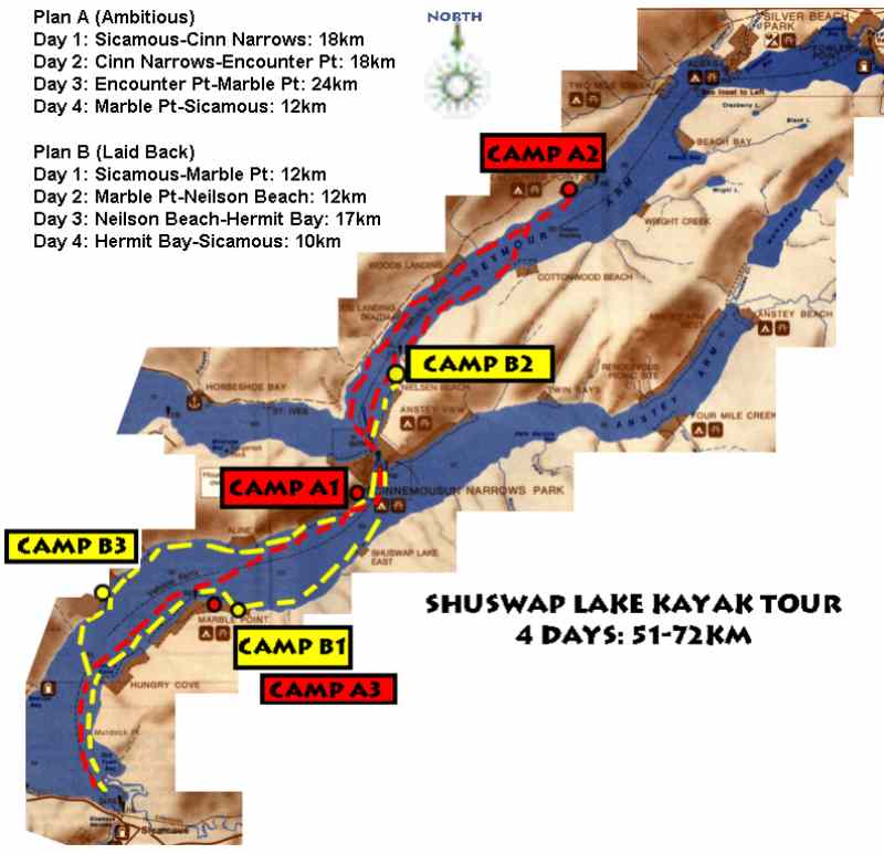
Plan A: The Ambitious Tour
Day 1 - 18km, Day 2- 18km, Day 3 - 24km, Day 4 - 12km
Plan B: The Laidback Tour
Day 1 - 12km, Day 2- 12km, Day 3 - 17km, Day 4 - 10km
*************************
1999 June 28, Monday 7:30PM
McDougall Center, Calgary
455 - 6 Street SW
*************************
Tour Co-Ordinator: Peter LaGrandeur
Calgary, Alberta
Webmaster: P. LaGrandeur......This page last updated 2005 Jan 29
Tour Overview
Participants understand this trip is a Common Adventure
where each participant conducts him/herself independently, makes his/her own judgements about
safety and well being, takes full responsibility for his/her own actions, and contributes whatever
he/she can towards the success of the trip. The Tour Co-Ordinator is not a leader or
professional guide of any type and acts only to provide basic logistical arrangements
for initiating and running the trip. The route, itinerary and all other aspects of this
trip are only suggested and, as responsible tourists, each participant is expected to
research everything prior to the trip to whatever extent he/she feels is necessary
to determine that all is safe and suitable. Each participant is expected to possess
any skills, equipment, fitness, common sense, etiquette, knowledge of applicable
legislations, etc., to enjoyably and safely be involved in this activity. Each
participant is the sole and final judge about his/her capability to safely proceed
with this tour. All participants recognize financial loss, physical injuries and death
to be real possibities facing anyone in the sport of kayaking and related activities
and agree to assume all risks and consequences. Any person who does not feel confident or self reliant
about their abilities or who does not agree with this philisophy should not
participate on this tour.
General

This four day self supported kayak tour
will take us through two or more arms of the Shuswap Lake system. Two trip itineraries have been developed
for this outing. Which one we end up doing depends on factors such as weather, paddler endurance
and our inclinations.
The weather in the west arms of the Shuswap Lakes system tends to be calmer than many other
lakes, and that is likely why there are few sailboats in these reaches.
However, infrequent squalls should still be prepared for.
There is more chance of inclement weather in this earlier part of the summer so
participants should be prepared for the occasional sprinkle.
Water levels will be noticeably higher at this time of year compared to later in the summer.
Some of the beaches will be submerged. The water level changes at least three feet in
the lake system over the course of the summer months.
Paddlers must be prepared to bring everything they require IN their kayaks.
There will be no access to us for any support persons or visitors with
land based vehicles.
A touring kayak (not whitewater kayak) would be the ideal style of boat for this trip. Open Canadian canoes
would also be suitable but participants with those boats are advised that it takes more
energy to go the distance than with kayaks. Canoes, with their high freeboard,
are also more vulnerable to wind and waves. Composite construction boats would be fine for this
trip because, with the longer distances, and with their slightly smoother wetted surfaces, they
may afford the expenditure of less energy by their paddler, possibly 5%.
Please link to the post trip photo album.
Maps
Participants are advised to carry
the "Provincial Parks of the Shuswap" map available by calling 250-851-3000, and the "Salmon Arm
Forest District Recreation Map" from 250-833-3432. Map afficiondos may be interested in other maps:
Parking in Sicamous for Four Days
It is not a good idea to leave vehicles parked in public areas in Sicamous due to car prowler problems. It has been arranged to leave our cars in a resident's private vacant lot for our stay. The lot is adjacent to the west side of 209 Finlayson. This place is about two blocks straight east of the ferry landing on the north side of the Trans Canada highway on the east side of Sicamous Narrows. These narrows are the connector between Mara Lake and Shuswap Lake. The caretaker of the lot, Alex (250-836-2038), will charge $4 per day to leave vehicles there.
Fees
No money will be collected by the Tour
Co-Ordinator for this tour. Participants will pay all their own expenses along the way.
All participants should be sure to buy a
which will allow them to use any Prov Park over nighting facility along the shores. These may be
found at the following places. We are supposed to have these permits before we get onto the
water. Try to get yours the evening before or first thing the next morning.
I hear they cost about $8 per night per boat.
SHUSWAP LAKE MARINE PROVINCIAL PARKS CAMPING PERMIT VENDORS - 1998
Anglemont
Cinnemousun Narrows
Seymour Arm
Camping Permits must be purchased in advance from one of the vendors listed
Bastion Bay
(end of Sunnybrae Road)
Canoe
Salmon Arm
Scotch Creek
Sicamous
Squilax/Sorrento
Orientation Documentation
This internet information will serve as the orientation package. No handouts will be issued. Participants may output this web page onto their own printing equipment.
Accommodation Availability
Participants wanting accommodation other than the designated lakeside campsites must look after all their own arrangements. The itinerary we end up going on is entirely dependent on the weather and on skill and endurance of the participants.
| Plan 'A': Ambitious Trip | |
| Night 1 | Cinnamousin Narrows |
| Night 2 | Encounter Point |
| Night 3 | Marble Point |
| Plan 'B': Laidback Trip | |
| Night 1 | Marble Point |
| Night 2 | Neilson Beach |
| Night 3 | Hermit Bay |
Camping Skills
As with any outdoors trip, there could be constant sun and dry nights, or continuous rain.
Be prepared for relentless drizzles. Even if an overnight rain is short, all your tent and
sleeping gear could become totally
soggy. It is always best to have a separate tarp OVER your tent and fly. This will keep your
entire shelter assembly dry, even in the setup and takedown phases. It is no fun having to set up a
tent at the end of the day that is still dripping from that morning, especially after there was no
chance to dry it out during the day. SKILLFUL campers can go day after day in the rain if they are
properly equipped and experienced. Skill, experience, and preparation means the difference between
a continued journey in nature's precipitous environment and a miserable hypothermic disaster that turns
a person into never wanting to go again. Of which category are YOU??
No one needs to haul water in their boats as long as they have filtration and purification equipment
with them. This technology is within reach of the average consumer nowadays so let's see some elbow
grease working those little pumping units.
Never forget the bug dope in the great outdoors. And the bear repelling spray. And the sun block with
the sun glasses. And the big floppy hat to help avoid heat stroke/exhaustion.
Bring clothes for ALL types of weather. Anything from snow and cold wind that whips cold water
across you to stifling humid still heat could await us. Neoprene full length "farmer john" style
wet suits are a REQUIREMENT for this tour. DON'T COME on this trip without a neoprene wet suit,
even if the weather forecast calls for a week of +30C weather.
You don't always have to wear it, but you should always have it with you for when the weather does
something that was not forecasted.
Plus a WATERPROOF paddling jacket. A good anorak may
get you by but a proper paddling top is better. Be sure to have either neoprene booties or, at minimum,
thick wool socks inside of running shoes. No rubber boots, please. You can't swim in gum boots,
so do not make a spectacle of yourself trying. And, last but not least, some neoprene mitts or gloves.
Pogies are wonderful to have. These are neoprene gloves that also go around the paddle shaft. Those
who do not have neoprene hand wear could get along with wool mitts inside of windproof outer mitts.
Need I have to remind anyone that a PFD (Personal Flotation Device) is required for every boat occupant.
And starting this year, each paddle boat has to have a heaving line; a 'throw bag' will do.
It goes without saying that everyone should have first aid skills. This is a basic life skill that all
persons should have.
Meals
Participants must bring some means of supplying and preparing all their meals out of their boats. Be sure to bring high energy foods that deliver short and long term energy supplies to the body. On this trip, you will have room to bring more bulky foods, if desired (e.g. canned goods), since we do not have to carry it on our backs, since we will have extra room that is normally taken up by water, and we are going for only four days. We will have lots of room for the little camp stoves, so everyone can bring their own.
Problem Partiers
There are resident park operators at Cinnemousun Narrows, so parties are not a problem anywhere near the main camping area, and there haven't been many problems in other sections either. Also no particular problems at Anstey View, Twin Bays or Four Mile Creek. The other place where there has been trouble with parties is Marble Point, but because of the size and shape of the park there should be a place there where we won't be bothered. We are encouraged to call the Marine Rangers or the park operators if we do encounter loud parties or other inappropriate behaviour. Those who have cell phones, can call the Rangers at 250-319-0271 or 250-319-1471. If there is no access to a phone, stop by Cinnemousun Narrows and tell the park operators. Take note of boat names, time and location. If the problem is caused by a rental houseboat, the houseboat company will often take away the damage deposit, seize the big speakers, etc.
Fire Wood
Firewood must be purchased in Sicamous before departure, or from the park operator at Cinnemousun Narrows. There have been serious problems with tree-cutting in the marine parks and any violators are charged. Use of driftwood on the beach is OK, but this supply tends to get used up quickly.
|
Itinerary & Waypoints |
|
| Plan "A": Ambitious Trip | Plan "B": Laid Back Trip |
|
|
|
Map |
|
|
|
Links and Contacts |
|
Are You Possibly Interested in Participating?
If So, Please Submit the Following Information:
|
|
|
|