 We will be paddling the reach of the Milk River that starts just south east of the
Milk River town site and ending about 35km due east at the Alberta Provincial Park,
Writing On Stone. Total river kilometers add up to about 69.
We will be paddling the reach of the Milk River that starts just south east of the
Milk River town site and ending about 35km due east at the Alberta Provincial Park,
Writing On Stone. Total river kilometers add up to about 69.
We will be journeying through prairie savannahs, sculptured canyons and badlands. Canoes will be a convenient way of observing the riparian environment within the confines of the river valley.
This is a trip on Grade I moving water for people who already know how to paddle a canoe/touring kayak, how to steer it comfortably, and who can handle Class I rapids. Stern paddlers should definitely know what they are doing, albeit there could be a novice in the bow seat. Take a course in canoeing ahead of time, if necessary. This is not the time and place to try to learn from scratch. The current reputedly flows at an average speed of 4kph.
Canoes or sea kayaks made from PLASTIC ONLY are strongly recommended. DO NOT, repeat, DO NOT, bring a double kayak. The river is too narrow, has some rock gardens, and there are Class I rapids for long boats.
To go paddling, each participant must have a PFD, a bailer, a throw rope bag, a sound signalling device such as a whistle, and a paddle plus one extra paddle per boat. Wet suits, paddling jackets, neoprene gloves/mitts, wet suit boots or strong runners with thick wool socks, should be brought with each participant and carried in their boat in the event of inclement weather.
Please link to the post trip photo album.
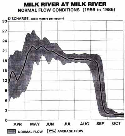
Participants should be checking the river flow reports for the Milk River from Alberta Environment. These documents are in industry standard Adobe Acrobat electronic publishing format. The reader software for this is required to view these documents. For those visitors to this web site who do not have the free Acrobat Reader software may download and install it to their systems by clicking the Acrobat button below.
As with any outdoors trip, there could be constant sun and dry nights, or continuous rain. At least be prepared for relentless drizzles. Even if an overnight rain is short, all your tent and sleeping gear could become totally soggy. It is always best to have a separate tarp OVER your tent and fly. This will keep your entire shelter assembly dry, even in the setup and takedown phases. It is no fun having to set up a tent at the end of the day that is still dripping from that morning, especially after there was no chance to dry it out during the day. SKILLFUL campers can go day after day in the rain if they are properly equipped and experienced. Skill, experience, and preparation means the difference between a continued journey in nature's precipitous environment and a miserable hypothermic disaster that turns a person into never wanting to go again. Of which category are YOU??
Never forget the bug dope in the great outdoors. And the bear repelling spray. And the sun block with the sun glasses. And the big floppy hat to help avoid heat stroke/exhaustion.
We will be camping along the river on the Saturday night so bring all your gear with you in your boat in waterproof containers. Be sure to have some means of tying in these containers in the event of an upset.
Always bring clothes for any weather, regardless of what the forecast calls for. As usual, as with any outdoor pursuits overnight trip, be able to camp and be comfortable in rain.
Either bring all your own drinking water or your filtration and purification gear.
Participants must bring some means of supplying and preparing all their meals out of their boats. Be sure to bring high energy foods that deliver short and long term energy supplies to the body. On this trip, you will have room to bring more bulky foods, if desired (e.g. canned goods), since we do not have to carry it on our backs, since we will have extra room that is normally taken up by water, and we are going for only two days. We will have lots of room for the little camp stoves, so everyone can bring their own.
Any fires built from the sparse supplies of drift or shore dead fall wood have to be done so at the river's edge where all evidence will be washed away at the next high water. If the environment is dry at the time of our trip, fires may not be allowed at all.
Participants should be checking the weather forecast for the Lethbridge area:
- (403) 299-7878 (Calgary access #)
- Environment Canada Weather
The Writing on Stone Provincial Park information phone number is (403) 647-2364. This long distance call may be made for free during business hours by calling the Province of Alberta's RITE number at 310-0000 and asking for WOS's above #.
The area's prevailing winds usually come from the south east and are often blowing to some extent. It goes without saying that everyone should have first aid skills. This is a basic life skill that all persons should have.
No money will be collected by the Tour Co-Ordinator for this tour. Participants will pay all their own expenses along the way.
One reference book for this canoe trip could be "Canoeing Alberta" by Janice E. MacDonald et al, pp. 66-70 1st edition, from Lone Pine Publishing. ISBN 0-919433-28-6 The following excerpt comes from this document:
The Milk River is the only Alberta river that flows to the south. It is part of the Mississippi-Missouri drainage system, joining the Missouri River which eventually drains into the Gulf of Mexico. It is formed from several small streams that arise in southeastern Alberta and northern Montana, east of Glacier National Park.
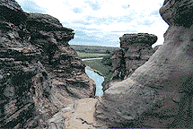
The river flows through four distinct physical areas: the plains, Writing On Stone Provincial Park, the barrenlands, and the canyon badlands. Unchanged since the arrival of the first explorers, the region contains the last native grasslands in Alberta.
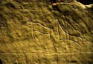
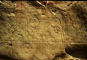
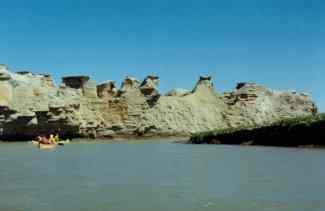
With Montana's Sweetgrass Hills dominating the skyline to the south, the Milk River Valley is probably the most spectacular on the southern Canadian plains. Rare outcrops of igneous rock such as the 30m hill known locally as Black Butte can be seen among the gravel and clay cutbanks of the upstream section of the river. Eventually these cutbanks give way to sandstone cliffs, with erosion providing amazing examples of hoodoos and tablerocks. The river flows through Writing On Stone Provincial Park, an archaeological preserve containing the largest indigent rock art site in Alberta. At this point, the river valley which is moist and protected, becomes profuse with cottonwoods, large shrubbery, and other lush growth. Larger mammals, especially pronghorns, are attracted to the river valley, as are a variety of both waterfowl and birds of prey.
 Let's try to be ready to move out of camp by 09:00. Leave as many vehicles
as possible at the Writing on Stone campground in an out of the way location.
From there, we all go in as few vehicles as possible to Gold Springs park just
east of Milk River. Everyone bring roof racks for boats on this trip! We
will put our boats in the water at Gold Springs. This has already been
arranged for us to leave our vehicles there until the following afternoon.
After loading our gear into the boats, we begin our tour of the picturesque
Milk River valley. The Class I - II sections of the river are between Coffin
Bridge and Poverty Rock.
Let's try to be ready to move out of camp by 09:00. Leave as many vehicles
as possible at the Writing on Stone campground in an out of the way location.
From there, we all go in as few vehicles as possible to Gold Springs park just
east of Milk River. Everyone bring roof racks for boats on this trip! We
will put our boats in the water at Gold Springs. This has already been
arranged for us to leave our vehicles there until the following afternoon.
After loading our gear into the boats, we begin our tour of the picturesque
Milk River valley. The Class I - II sections of the river are between Coffin
Bridge and Poverty Rock.
 Break camp again by 09:00. Continue on down the river to Writing on Stone
Provincial Park. We will land at the beach area in the park in early
afternoon giving us all plenty of time to drive back to Calgary and
arriving in reasonable time for an early retiring.
Break camp again by 09:00. Continue on down the river to Writing on Stone
Provincial Park. We will land at the beach area in the park in early
afternoon giving us all plenty of time to drive back to Calgary and
arriving in reasonable time for an early retiring.